The Baumgartenschneid (1448 m) offers something for everything – especially for beginners – with both stunning views of Lake Tegernsee as well as a lovely hut to stop at for refreshments . This circular tour is a fantastic choice for those looking for an accessible hike around Tegernsee when travelling from Munich without a car.
Details & Directions
| Parking & Start: | Hiking Car Park Alpbachtal or Tegernsee Train Station. |
| Difficulty: | Medium |
| Distance: | 11 km |
| Duration: | 4:00 hours |
| Ascent: | 680 hm |
| Public Transport: | BRB to Tegernsee Train Station |
Route to Baumgartenschneid
Tegernsee Train Station – Hiking Car Park “Alpbachtal” (0:15h) – Berggaststätte Riederstein am Galaun (1:00h) – Baumgartenschneid (2:00h) – Hiking Car Park “Alpbachtal” (3:45h) – Tegernsee Train Station (4:00h).
The Baumgartenschneid Hike from Tegernsee
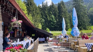
Those arriving with the Bavarian Regiobahn (BRB) will start the hike just south of the Tegernsee train station on Max-Joseph-Straße, heading in an easterly direction. Shortly before the Alpbachtal hiking car park, cross the Alpbach and follow the signposted forest path towards Riederstein or Baumgartenschneid. The steadily ascending forest path soon turns into a shady, well-signposted hiking trail. After about an hour, you will reach the Riederstein mountain restaurant (Gasthaus Riederstein am Galaun). From here you can finally see the Riederstein on the horizon .

At this point, most hikers add on the short climb up to the Riederstein Chapel via the steps – be sure to bring spikes or hiking poles in winter as the steps can be very slippy .

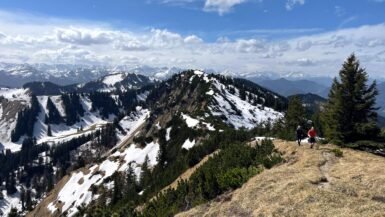
As the trail continues through the forest towards Baumgartenschneid, the trail markings become somewhat difficult to see, particularly in autumn. Shortly before Baumgartenschneid, the trail marking become more obvious again and the path to the summit is obvious. No climbing or special moutaineering skills are required.

Trotz des vergleichsweise einfachen Aufstiegs ist der Ausblick phänomenal: man hat einen herrlichen Blick auf die Gipfel der gegenüberliegenden Tegernsee-Seite. Hierzu zählen unter anderem der Hirschberg, Roß- und Buchstein mit der Tegernseer Hütte, Fockenstein, Kampen, Leonhardstein und Schildenstein.
Descent from Baumgartenschneid
The descent from the Baumgartenschneid back to the starting point of the circular tour leads through the Alpbachtal. The hiking trail crosses the summit in a northerly direction, shortly after the descent you come to the Baumgartenalm (which is not open to the public) and the hiking trail branches off into the shady forest. The narrow path is again not particularly well marked and can be difficult to see, especially in autumn when it is covered by leaves.

After about three quarters of an hour downhill, a bridge over the Alpbach and a forest path lead back to either the hiking car park or the Tegernsee train station.

Alternative Decent Towards Schliersee
The Baumgartenschneid is located right between Tegernsee and Schliersee. That means it’s possible to ascend or descend from both lakes. And the Bavarian Regiobahn runs from and to Munich from both Schliersee and Tegernsee stations.
Between the two lakes, hikers will find a well-developed and signposted network of paths that allows for various routes. In addition to the descent back to Tegernsee station described above, there is another popular descent towards Hennererhof and Schliersee. It is also possible to descend via the Kreuzbergalm and/or the popular Gindelalm.
Summary
Those who enjoy the hike to Neureuth, will also enjoy the Baumgartenschneid circular tour, which we consider the second beginner’s tour on the eastern side of Lake Tegernsee. If you’re looking for a particularly scenic hike at Tegernsee that doesn’t require a car to get there, the Baumgartenschneid hike is a fantastic option.